Hi ,
The Grand Canyon area is a very fascinating topic. It is well established, even among many secular geologists, that it couldn't have happened slowly over millions of years. Rather, it was a very dramatic event which happened rapidly. But, where did the water come from that could do such huge damage to the sedimentary layers in the Colorado Plateau
here?
Again, I refer to the work of Dr. Walter Brown, who long-ago proposed that there were two huge lakes on the surface of the plateau that had slowly grown after the flood ended due to water draining from the higher elevations. His proposal is that, at some point the dams holding these lakes gave way, releasing an incredible amount of water
very rapidly. This theory has great merit.
Among the arguments of those who disagree is that they don't see any evidence of the places where the lakes were. My response is that they choose not to see the evidence! It's everywhere you look when you are standing in places that would have been in the lake! In any event, the
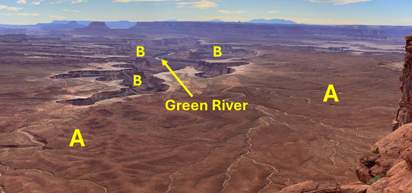
purpose of this is not to present the many points in support of this lake breach theory, but to show one interesting scene. The photo here is taken from the Green River Overlook in Canyonlands National Park. This one view is astounding!
When a lake is drained and the lake floor exposed, the original source of the water is normally still
evident. The stream or river continues to flow through the area, as it's doing today. However, if there was a lot of water contained within the sediments under the lake when all the water drained, especially if the draining was fast (catastrophic), those waters can escape rather dramatically during the rush. And when they do, collapses can occur all along the flow path of the main movement of water. That's exactly what is seen here! The Green River can be seen flowing at the tip of the yellow
arrow. This is the way it looks now. But, look at the areas represented at "B". These are the collapses as water rushed from under the floor of the lake ("A").